Home Artists Posts Import Register

Content

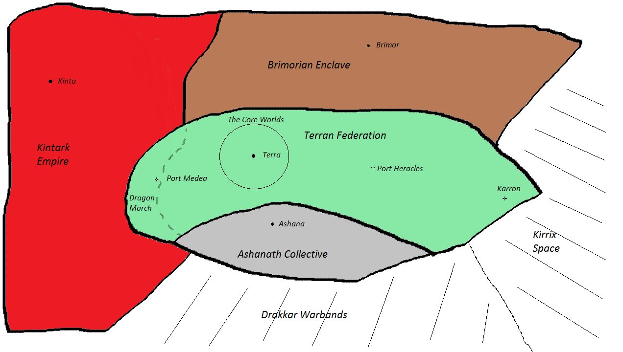
As I mentioned a few weeks ago, I was thinking about sketching out the Empire territory mentioned in the story.

I created two,  a plan view and the profile view. Here is a plan view, showing the various empires that have hemmed in the Terran Federation. 

Files

Comments

Anonymous

Thanks, Brimorians seem to have the largest territory. The Malari and Kintark might also due to perspective issues with flat maps.

Anonymous

To match up the two maps, I found it useful to rotate this map by 90 degrees so the Drakkar areas line up on the western side.

Evan

Please note that we only see a portion - and based on overall shape, a relatively small portion - of the Malari Regency. I suspect that we'll find out that the Malari Regency covers a lot more space than any of the others' areas of space. Personally, I find it more interesting that it's even called a Regency... as that clearly states in the title that it's a caretaker government until the rightful ruler comes to take his or her place. It was a title often used for caretaker rulers until the rightful ruler could mature. John?

Dwight Brown

John said that he wanted to go the Brimorians also to upgrade his ship. He did not say what they had that he wanted.

Jedi Khan

Shields. The Brimorians have the best shield tech around.

Anonymous

Did Terran Federation had wars with Brimorians in the past ? I remember when Irillith hacked into Mars database there was mention of Brimorian Annex, but who annexed who ?

Anonymous

Another term for annex. Centralized location <a href="http://www.dictionary.com/browse/annex" rel="nofollow noopener" target="_blank">http://www.dictionary.com/browse/annex</a> See last example. It's not just adding to something, or taking from something.

Anonymous

I don't think it applies to this, it was clearly territory annex.

prsstarid

there is a 3d Map some one did. https://myhub.autodesk360.com/ue284bed1/g/shares/SH56a43QTfd62c1cd968613d2324e5eb60a7?viewState=NoIgbgDAdAjCA0IDeAdEAXAngBwKZoC40ARXAZwEsBzAOzXjQEMyzd1C0B2T3GAFkZ8AxgFoAZkLEBOEXxhS%2BIxgCMAbACYRAVgAm03GL64dAZjGM0AXxABdIA

Anonymous

Remember that space is in 3 dimensions. There can be more species neighboring than you are showing in 2 dimensions.

Anonymous

I find myself wanting a 3d map I can rotate. It's hard work flipping back and forth between the two 2d maps and trying to create a virtual 3d model in my mind. A plan view plus both front and side elevations would help.

2ndAndrocentric

Are these prior to the annexation of half Kintark after battle of Terra? In other words, not just 3 dimensions, but four as time changes maps.