Home
Home

 Artists
 Search
 Recent
 Random
 Posts
Posts
 DMs
DMs
 Tags
Tags
 Random
 Importer
 Import
 FAQ
FAQ
 Account
 Register
 Favorites
 Login
Login

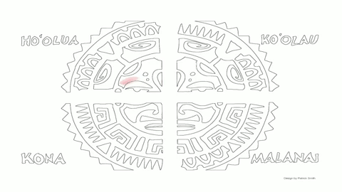
Polynesian Star Compass coloring book page #NovemberReward (Patreon)
Content
We might feature your work on our social media pages, in a future TED-Ed video, or even on the office fridge!
This image is from our lesson, How did Polynesian wayfinders navigate the Pacific Ocean? by educators Alan Tamayose and Shantell De Silva with animation by Patrick Smith. Did you know that Polynesian wayfinders navigated the Pacific Ocean at night using a star compass? This wasn't a physical object, but a mental map based on the rising and setting points of various stars throughout the year. They used this map to divide the sky into four quadrants, with their canoe in the middle.
When was the last time you used a mental map to navigate complicated terrain?
The coloring book page is attached to this post and most easily accessed by opening this post in your desktop browser.
Files