Home
Home

 Artists
 Search
 Recent
 Random
 Posts
Posts
 DMs
DMs
 Tags
Tags
 Random
 Importer
 Import
 FAQ
FAQ
 Account
 Register
 Favorites
 Login
Login

Conroy's Confusing Caves (Patreon)
Published:
2014-07-18 15:48:42
Imported:
2024-01
Content
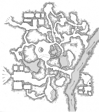
This cluster of caves leads to an underground river and was probably carved out in part by surface waters joining the subterranean waterway at some point. Some attempts have been made by various groups to build up sections of the caves (always near the surface entrances), but the presence (imagined or real) of squamous monstrosities living and travelling through the murky black waters generally keep civilized species from living here for long.
In the largest natural cavern there is a post driven into a small raised section of stone. The post has definitely been used to hold prisoners or sacrifices of some kind in the past, and perhaps a new cult worshiping the misshapen toad-things said to live here have brought back the use of this sacrificial platform.
This is one of those maps that was originally going to be something “easy” and “quick” for today’s post. I started on it yesterday with the goal of having it done, scanned and posted by evening. It’s now almost noon the next day and I’m finally done. The map just kept growing on me, getting more convoluted and demanding more detail. It was drawn using a pair of Sakura Micron pens (02 for walls, 01 for details, hatching and doors) on a pad of Canson 8-square-per-inch graph & layout paper. Post-production was done in photoshop (contrast enhancement, adding the water screen).