Home
Home

 Artists
 Search
 Recent
 Random
 Posts
Posts
 DMs
DMs
 Tags
Tags
 Random
 Importer
 Import
 FAQ
FAQ
 Account
 Register
 Favorites
 Login
Login

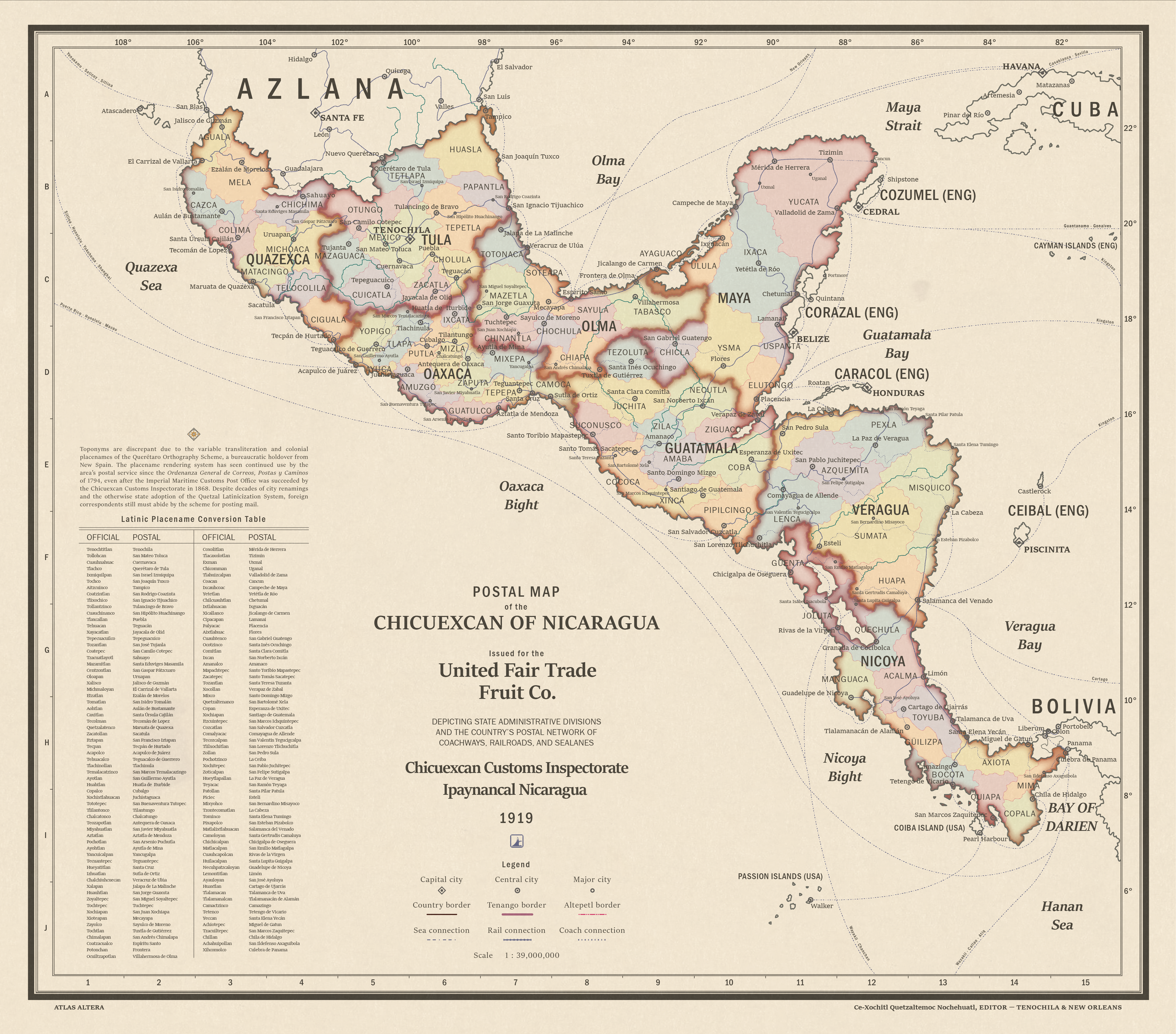
Free print-ready historical map of Nicaragua (Mesoamerica) (Patreon)
Content
With the help of a Nahuatl-speaker, I've been revamping the toponyms and ethnolinguistic borders for the Nicaragua (OTL Mesoamerica) part of the world map. This little historical postal map is a cool offshoot of our efforts.
The map depicts the Chicuexcan of Nicaragua, a federated state which once formed the culturally more resilient Indigenous part of the Spanish Main. Upon independence, these territories were at first conjoined with the more criollo-dominated territories of what is now known as Azlana (along with frontier territories further northwes in Arizona and in Texas) to form the Empire of Nicaragua. In 1846, the more Indigenous south revolted against centralization and the Hispanicization attempts of criollo elites, leading to a civil war that would see American intervention and a brokered peace plan that would lead to the Partition of Nicaragua, forming a Catholic and Spanish-speaking state in the north and a union of Indigenous altepetls or autonomous states in the south.

The reason the centralization and Hispanicization efforts that happened in OTL Mexico backfire in ATL is partially due to ATL New Spain having settler migration concentrated in the north (due to a lack of opportunity for newcomers in face of more resilient and entrenched Indigenous populations in the south, which you can kind of see in OTL Chiapas and Oaxaca anyway, as well as Guatemala), and partially because the colonial authorities balanced their power by co-opting Indigenous communities who were less devastated by disease and more politically enfranchised by the ejido system that Spain first brought over. From the balancing act came a distinct separation of identities in the colonial landscape, which, ironically, even though was feudal, gave some breathing room to Indigenous culture. For instance, did you know that Nahuatl's language range actually expanded during OTL New Spain up until Mexican Independence? It should be noted, however, that Nahuatl is only used as a lingua franca for inter-regional communication in the Chicuexcan (like Hindi in OTL northern India and English for OTL southern India), and that each altepetl of the federation has its own official language. In fact, with the revamp of Nicaragua, I'll have to do an update on this Septentrean Lects map.

For the toponym revamp, we had come up with real Nahuatl transcriptions, because the Altera world map is contemporary and the map style requires cities to be transcribed as endonyms. But for this period piece of a map, we decided to Hispanicize everything to produce the maximum amount of crazy-looking toponyms. Yes, we came up with something authentic, and then stained it with lore for a different kind of authenticity...one that echoes India's decolonization experience, where orthographies of city names are constantly being tweaked and colonial-imposed names are replaced with native ones. Don't worry, I'll be making a footnotes post with the spreadsheet of all the toponyms for easy referencing, along with the Nahuatl etymologies of each altepetl and tenango depicted in the map.

The inspiration for this creative bit of lore comes from the real history of Chinese postal romanization, which I've always found quite humorous. Like the Mayan-based script used in ATL Nicaragua, the Chinese writing system proved to be difficult for foreign correspondents to reference when posting mail. To solve this, romanization or transliteration of Chinese into the Latin script was necessary. As it was run by foreigners at the highest levels, the OTL Chinese Imperial Maritime Customs Service, and for a while, its successors, used their own romanization transcription system parallel to other state romanization systems.

Finally, the map's cartographic style is inspired by this kind of map, part of a collection of postal maps edited by one Ramón de S. N. A. Araluce. I never knew postal maps were a thing before, and it was quite a serendipitous occasion when I came across postal maps of Mexico just when I was thinking about doing some kind of funky incongruent toponym thing in line with the Chinese postal romanization history.
Finally, here's the download link to the print-ready version of the map.
Files